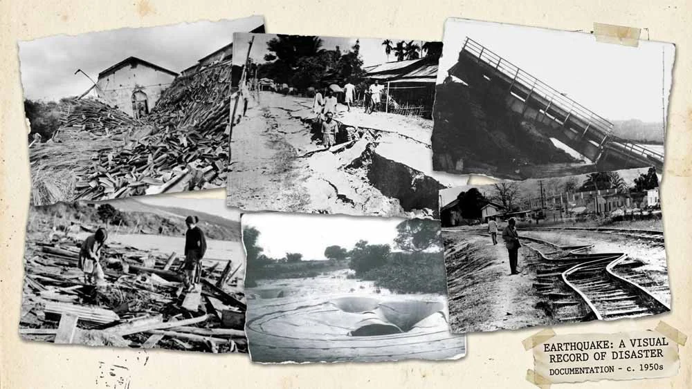
On the evening of 15 August 1950, as India marked its third anniversary of independence, the ground across Upper Assam began to heave. The shaking lasted several minutes. When it stopped, entire hillsides in the Mishmi and Abor Hills had slid into the valleys, rivers were blocked, railway lines were twisted and towns across the Brahmaputra valley lay damaged.
The earthquake had a magnitude of about 8.6 to 8.7. It remains the largest earthquake ever recorded on a continent, as opposed to beneath the ocean, and one of the largest of the twentieth century. Its effects on the landscape and rivers of Assam are still visible today.
This article explains what happened, why it happened, what it cost in human terms, how it reshaped the Brahmaputra valley, and what it means for a region that remains among the most earthquake-prone in the world.
Key facts at a glance
| Detail | Information |
|---|---|
| Date | Tuesday, 15 August 1950 |
| Time | 14:09 UTC (about 7:39 pm Indian Standard Time) |
| Magnitude | Mw 8.6 (USGS); 8.7 in several studies, including a 2020 reassessment |
| Epicentre | About 28.4°N, 96.5°E, near Rima (Zayü) in south-eastern Tibet, close to the Mishmi Hills |
| Focal depth | About 15 km (shallow) |
| Maximum intensity | XI on the Modified Mercalli scale |
| Duration of strong shaking | Several minutes (accounts vary from about 4 to 8 minutes) |
| Deaths in Assam | 1,526 (USGS and NOAA catalogues) |
| Deaths in Tibet | At least 780 (USGS), with later Chinese studies suggesting about 3,300 |
| Commonly cited total | About 4,800 |
Assam or Tibet? Naming the earthquake
The event is widely known as the “Assam earthquake”, but its epicentre lay just across the border in Tibet, near the town of Rima in today’s Zayü County. The American seismologist Charles Richter observed that, strictly speaking, it was not an Indian earthquake. Scientists today generally use the name Assam–Tibet earthquake. It is still remembered in Assam as the 1950 earthquake, because Upper Assam and the hills of present-day Arunachal Pradesh suffered the greatest property damage.
The scientific background: why here?
A collision zone at the corner of the Himalaya
The Himalaya exists because the Indian plate is pushing northwards into Eurasia. At the eastern end of the range, the mountain belt turns sharply south into the hill ranges along the Myanmar border. Geologists call this bend the Eastern Himalayan Syntaxis.
At this corner, three plates (the Indian, Eurasian and Sunda plates) interact, and the direction of the major faults changes. Stress builds up along these faults over centuries and is released suddenly in large earthquakes. The 1950 earthquake occurred right at this bend.
What kind of fault moved?
The 1950 earthquake happened before the theory of plate tectonics was established, and only a limited number of seismograms recorded it. As a result, its exact mechanism has been debated for decades. Earlier studies proposed either strike-slip movement (blocks sliding past each other horizontally) or thrust faulting (one block pushed up over another).
A 2020 study in Earth and Planetary Science Letters by Coudurier-Curveur and colleagues combined relocated aftershocks, landslide maps, satellite images and field work. It concluded that the earthquake ruptured two thrust faults: the Mishmi Thrust and the Main Himalayan Frontal Thrust in the Abor Hills. The researchers traced a surface rupture at least 200 km long and estimated that aftershocks and fresh landslides spread over an area of roughly 330 km by 100 km. Their analysis supports a moment magnitude of 8.7 and confirms the event as the largest continental earthquake on record.
How the earthquake was experienced
An eyewitness at the epicentre
By chance, one of the best-known accounts comes from very close to the epicentre. The British botanist and explorer Frank Kingdon-Ward was camping at Rima with his wife when the shock began. He described a terrible noise and violent shuddering of the ground, and later reported loud explosive sounds that seemed to come from high in the air. Similar sounds were reported at many places in India and Burma, more than 750 miles away. Kingdon-Ward later published detailed accounts of the earthquake and the devastated landscape in Nature and The Geographical Journal.
Felt across a vast area
The shaking was felt across Northeast India, Burma (Myanmar), East Pakistan (now Bangladesh), Tibet and south-western China. Estimates of the felt area range from about 1.8 million to 3 million square kilometres. The earthquake even caused water to oscillate in lakes and fjords in Norway and in reservoirs in England, thousands of kilometres away. Studying these effects, the Norwegian scientist Anders Kvale introduced the term “seismic seiche” in 1955.
Intensity across the region
Intensity measures how strongly shaking was felt and how much damage it caused at a particular place. Reported Modified Mercalli intensities included:
| Intensity | Places |
|---|---|
| X (very destructive) | Sadiya, Pasighat, Doomdooma, Dibrugarh, North Lakhimpur, Sibsagar |
| IX | Digboi, Golaghat |
| VIII | Tezpur, Guwahati, Shillong |
| VI | Dhaka, Kolkata, Dhubri, Darjeeling, Imphal |
A long sequence of aftershocks
The main shock was followed by numerous aftershocks, many of magnitude 6 or more, continuing for months. One aftershock a few days later was felt more widely in parts of Assam than the main shock. Some newspapers wrongly took this as evidence of a larger earthquake, an example Richter later used to explain the difference between magnitude (the energy released) and intensity (the shaking felt at a place).
The human toll
Casualty figures differ between sources, mainly because records from remote hill areas and from Tibet were incomplete.
| Area | Reported deaths | Source and note |
|---|---|---|
| Assam (including the hill areas now in Arunachal Pradesh) | 1,526 | USGS and NOAA catalogues; Steinbrugge gives 1,530 |
| Subansiri flood (within the Assam total) | 532 to 536 | Deaths when a landslide dam burst |
| Abor Hills landslides | 156 | About 70 villages destroyed |
| Tibet | at least 780 | USGS figure for the Nyingchi–Qamdo–Zayü area |
| Tibet (later estimate) | about 3,300 | Chinese study by He and colleagues (2018) |
| Total (commonly cited) | about 4,800 | Combining Assam and later Tibetan estimates |
The USGS notes that the casualties in some of the worst-hit Tibetan areas were never fully counted, so the true toll may be higher. In Medog County, the village of Yedong is reported to have slid into the Yarlung Tsangpo (the upper Brahmaputra) and been washed away.
Beyond deaths, losses were very large. Farmers are estimated to have lost tens of thousands of cattle. Wells, granaries and homes were destroyed. Contaminated water contributed to outbreaks of cholera and other diseases in the weeks that followed. The USGS records that property losses in Assam exceeded those of the great earthquake of 1897.
Landslides, river dams and floods
The deadliest effects of the earthquake came not from collapsing buildings but from the mountains themselves.
Landslides on a massive scale
The shaking stripped forests and soil from steep slopes across the Mishmi and Abor Hills. Pilots flying over the area afterwards reported dramatic changes in the topography. Millions of tonnes of rock, soil and trees poured into the rivers. Chinese sources describe the landslides on the Tibetan side as among the largest earthquake-triggered landslides in their country’s history.
The Subansiri disaster
Landslides blocked several tributaries of the Brahmaputra, creating temporary lakes behind natural dams of debris. The dam in the Dibang valley broke without causing major harm. The one on the Subansiri was different. About eight days after the earthquake, it gave way and released a wall of water about 7 metres high. The flood swept through villages downstream and killed more than 500 people.
Rivers out of control
All the major rivers of Upper Assam rose sharply, carrying sand, mud, uprooted trees and debris. In a radio broadcast to the nation in September 1950, Prime Minister Jawaharlal Nehru described how the Brahmaputra had been blocked for a while and then broke through, flooding wide areas and carrying away villages, animals and timber.
How the earthquake reshaped the Brahmaputra valley
The longest-lasting effect of the 1950 earthquake was on the rivers. The vast quantity of landslide sediment travelled downstream for years, raising riverbeds and making channels shallower and wider.
Studies of Upper Assam describe how, after 1950, the Brahmaputra’s channel belt widened rapidly in the Dibru–Saikhowa stretch, with banks moving on both sides. Elderly eyewitnesses interviewed by researchers recalled a much narrower river before the earthquake. Liquefaction, in which water-saturated soil temporarily behaves like a liquid, cracked the ground and weakened riverbanks, making them easier to erode.
The consequences shaped life in Upper Assam for decades:
- Erosion of towns and land. Parts of riverside settlements were lost to erosion, and the town of Dibrugarh became dependent on embankments for protection.
- Changing river courses. Some rivers abandoned their old channels. Sadiya, once an important frontier town, was badly affected by shifting rivers.
- More frequent flooding. Raised riverbeds meant the rivers overflowed more easily during the monsoon.
- Displacement. Families who lost their land to erosion were often resettled elsewhere, sometimes on forest or grazing land.
The Brahmaputra’s high sediment load, frequent floods and severe bank erosion have many causes, but the 1950 earthquake is widely regarded as a major turning point in its modern behaviour.
Damage to infrastructure and the economy
The earthquake struck the economic heart of Upper Assam:
- Railways and roads. Railway tracks and bridges were destroyed, including the Dibrugarh–Saikhowaghat line, and services were suspended. Roads buckled and wooden bridges collapsed. For a time, wireless radio was the main link with the outside world.
- Buildings. The USGS reports around 2,000 houses, temples and mosques destroyed. Contemporary press reports gave much higher numbers of damaged buildings and granaries across the affected area.
- Tea gardens. Many plantations in Upper Assam suffered from shaking, flooding and silt deposits.
- Agriculture and forests. Fields were buried under sand and silt, forest resources on the hills and riverbanks were badly damaged, and land revenue fell.
Relief and response
India in 1950 was a young republic with limited resources, yet the relief effort was substantial. Nehru visited the region and toured affected areas by air. On 9 September 1950 he made a national radio appeal for help for the victims and specially praised the staff and students of the Medical College at Dibrugarh for their work.
The Indian Air Force dropped supplies and evacuated stranded people from cut-off areas. The Assam Rifles helped reopen roads and railway lines, and tea garden workers, students and local volunteers joined the relief work. Funds were collected through national and state relief funds, with contributions from across India and abroad.
Comparison with the 1897 Assam earthquake
Assam has experienced two great earthquakes in just over fifty years.
| Feature | 1897 Great Assam (Shillong) earthquake | 1950 Assam–Tibet earthquake |
|---|---|---|
| Date | 12 June 1897 | 15 August 1950 |
| Epicentral region | Shillong Plateau, Meghalaya | Near Rima, south-eastern Tibet, close to the Mishmi Hills |
| Approximate magnitude | About 8.0 to 8.1 | About 8.6 to 8.7 |
| Most affected areas | Shillong, lower and central Assam | Upper Assam, Mishmi and Abor Hills, south-eastern Tibet |
| Notable effects | Widespread ground cracks and building collapse | Massive landslides, river dams, floods and long-term river changes |
The 1897 earthquake was studied in detail by the Geological Survey of India and became a landmark in seismology. The 1950 earthquake was larger and, according to the USGS, more damaging in Assam in terms of property loss.
Why the 1950 earthquake still matters
A clear warning about earthquake risk
Northeast India lies in Seismic Zone V, the highest earthquake hazard category in India’s seismic zoning map. The 1950 earthquake showed that the eastern Himalaya can produce earthquakes of magnitude 8.6 or more, and that landslides and floods can kill as many people as collapsing buildings.
The region has experienced several earthquakes of magnitude 7 or above in the past century. Seismologists have also identified long-quiet stretches of the Himalaya where stress is believed to be accumulating, which could produce a comparable event in the future.
Greater exposure today
As the geologist C.P. Rajendran noted on the earthquake’s 75th anniversary, the key difference between 1950 and today is how much more is now exposed to risk. Upper Assam and Arunachal Pradesh have far larger populations, more towns, highways, bridges and large hydropower projects on Himalayan rivers. Both India and China are developing hydropower on the Brahmaputra system near the source zone of the 1950 earthquake, which raises important questions about dam safety in a seismically active region.
Lessons for preparedness
The 1950 earthquake points to several practical lessons:
- Build to code. Buildings in Seismic Zone V should follow the Bureau of Indian Standards earthquake codes, and older public buildings such as schools and hospitals need assessment and strengthening.
- Plan for secondary hazards. Landslide dams and sudden floods require monitoring and early warning systems for downstream communities.
- Protect river communities. Land-use planning should account for erosion and shifting river channels.
- Prepare people. Community awareness, evacuation drills and emergency plans save lives, especially in remote areas that may be cut off for days.
Conclusion
The earthquake of 15 August 1950 was one of the most powerful natural events of the twentieth century, and it permanently changed the landscape of north-eastern India and south-eastern Tibet. It killed thousands, brought down mountainsides, dammed and released rivers, and set the Brahmaputra on a new course of sedimentation, flooding and erosion that communities still live with today.
More than seventy-five years later, the scientific understanding of the earthquake has improved greatly, but some questions about its source remain open. What is not in doubt is its central lesson: in one of the world’s most active earthquake zones, preparedness, sound construction and careful development are essential.
References
Scientific and official sources
- United States Geological Survey. Historic Earthquakes: Assam–Tibet, 1950 August 15 (archived page). Magnitude, intensities, casualties, Subansiri flood, seiches.
- Coudurier-Curveur, A., Tapponnier, P., Okal, E., Van der Woerd, J., Kali, E., Choudhury, S., Baruah, S., Etchebes, M. and Karakaş, Ç. (2020). A composite rupture model for the great 1950 Assam earthquake across the cusp of the East Himalayan Syntaxis. Earth and Planetary Science Letters, 531, 115928.
- Kingdon-Ward, F. (1953). The Assam earthquake of 1950. The Geographical Journal, 119(2), 169–182.
- Reddy, D.V., Nagabhushanam, P. et al. (2009). The great 1950 Assam earthquake revisited: field evidences of liquefaction and search for paleoseismic events. Tectonophysics, 474(3), 463–472.
- Richter, C.F. (1958). Elementary Seismology. San Francisco: W.H. Freeman. (Cited via USGS.)
- Rajendran, C.P. (2025). The 1950 Assam–Tibet earthquake: a singular Himalayan earthquake on its 75th anniversary. GeoLog, European Geosciences Union.
Historical sources
- Sharma, A. and Zaman, F. (2019). The great Assam earthquake of 1950: a historical review. Senhri Journal of Multidisciplinary Studies, 4(1), 1–10.
- Nehru Archive. Help to Victims of the Earthquake, radio broadcast, 9 September 1950.
- Patowary, A. Upper Assam most affected by 1950 earthquake. The Assam Tribune.
Further reading
- Wikipedia: 1950 Assam–Tibet earthquake (summary and bibliography).
- Bureau of Indian Standards. IS 1893 (Part 1): Criteria for Earthquake Resistant Design of Structures (seismic zoning).